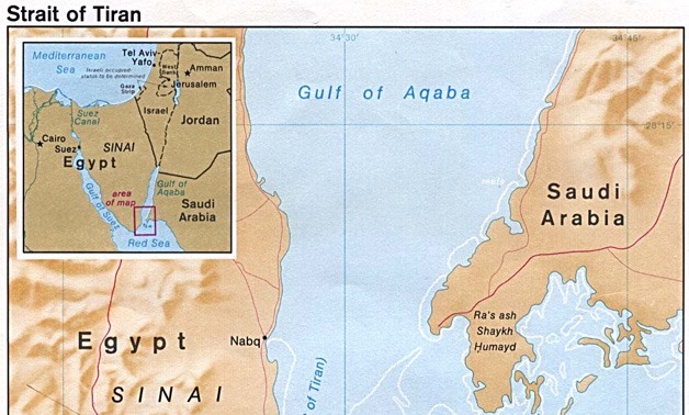
Strait of Tiran- photo via Wikimedia Commons
With the advance of discussing the Saudi-Egyptian border demarcation agreement, which has affirmed that the two islands belong to Saudi Arabia, a number of specialized and research establishments have worked for probing into the origins of the issue, in order to extract the truth about the islands’ identity.
One of these establishments is the Egyptian Geographic Society (EGS.) According to past statements made by Professor Sayid al-Hosseiny, president of the Egyptian Geographic Society, the state of Egypt has nothing to prove that the islands are Egyptian because all the EGS’s maps, which were reviewed for the case attest that Egypt had made an agreement with Saudi Arabia in 1950, by which the former was granted by the latter the right of protecting and defending the islands so as to prevent it from falling in the hands of Israel.
In his statements, Hosseiny also added that the ruling was issued after the examination of 160 official Egyptian maps of EGS, which date back to more than 100 years ago and in which the islands appear in a color that is different from the rest of Egyptian lands, which can only indicate that the islands are not part of Egypt. Moreover, many of these maps clearly show the islands as part of the Saudi lands. He also declared that all official correspondences and documents affirm Saudi sovereignty over the islands, adding that should the case be taken to the International Court of Justice, it will transfer the islands to Saudi Arabia after the first sitting. Among the examined maps are old maps, which date back to 1870 and include the South of Sudan within the borders of Egypt as an Egyptian directorate.
Legal documents including historic boundary demarcation agreements also referred to a considerable number of maps among which is the 1928 Egyptian Atlas maps no. 3 and 6. Meanwhile, map no. 3, which shows the topographical features of the Sinai peninsula and the north-east of Egypt down to El-Badari in Assiut in the south, also shows Tiran and Sanafir in a white color like Saudi lands, whereas the Egyptian islands which lie on the western coast of the Red Sea, such as Shadwan and Gopal islands, are shown in the map in the same color as the rest of Egyptian lands. Likewise, map no. 6, which is a general geographical map of Egypt, shows Tiran and Sanafir as colorless, in contrast to the colored Egypt in the rest of the map. Moreover, Egyptian economical map no. 32 shows the islands in white just like the rest of Saudi land on this map, whereas Sinai is shown in the same color as the rest of Egyptian lands.
The historic documents also referred to the 1984 World Atlas which includes a map for the Levant, north-east Egypt and Sinai and in which the international political borders are defined in red and the lines separate Tiran and Sanafir from Egyptian lands and include them within Saudi borders. In addition, the 1922 Atlas of the Country of Egypt, the Sinai Geological Atlas, the Sinai Geomorphological Atlas, Egypt’s Space Atlas and the French Campaign in Egypt Atlas, do not say that the islands belong to Egypt. The documents included all the maps, Atlases and official documents between the two countries, and treats the subject from a rigidly scientific perspective.
The documents also referred to the fact that the two islands have not appeared in geographical literatures before the State of Israel was established in 1948, and maps at the time did not include them within Egyptian borders, which could be due to the fact that international maritime borders agreements at the time considered coastal islands as extensions to the landmasses they are adjacent to even if there were no clear agreements concerning them. The most significant reference about this particular subject is perhaps Noam Shuqair’s book which dealt with the uncertainty around Sinai, and in his book he concluded that Egyptian borders started from Rafah in the east to Taba, and along the western coast of the Gulf of Aqaba to Ras Mohamed, and included Pharaoh Island within Egyptian borders whereas he did not mention Tiran and Sanafir whatsoever and they remained part of al-Hejaz, and were automatically included under Saudi sovereignty when Saudi Arabia was established in 1932.
The document added that the islands are, geologically, part of the Saudi landmass, while the islands lying on the east of the Strait of Tiran are topographically a Saudi pier, or part of the Saudi lands flooded by sea water in other words. The document also noted that the two islands had been uninhabited for a long time because of the harshness of their terrain, and their strategic importance only became clear after Israel occupied Eilat and consequently the necessity for controlling the entrance of the Gulf of Aqaba arose throughout the Arab-Israeli conflict.
The book also draws attention to the fact that Egyptian sovereignty over the islands started in 1949 as an agreement between Saudi Arabia and Egypt. After the 1973 victory, and after the region became stable, Saudi Arabia demanded that the islands be transferred back to its sovereignty, since the state of war with Israel had ended and the islands no longer hold the same strategic and military importance. In that respect, official documents affirm that Saudi Arabia did not ask Egypt to return Tiran and Sanafir except after the peace treaty between Egypt and Israel was made. Finally, the documents note that owing to all the above mentioned facts, presidential mandate no. 27 for the year 1990, which redefined territorial waters of Egypt implies the exclusion of Tiran and Sanafir from these waters.

Comments
Leave a Comment