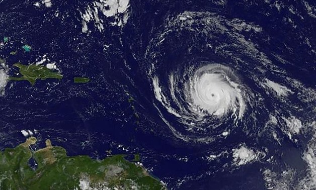
This image obtained from NASA's GOES Project shows Hurricane Irma churning near Caribbean islands on Tuesday -AFP
5 September 2017: Irma, a still strengthening and dangerous Category Four hurricane, churned toward the Leeward Islands early Tuesday, sparking alarm and alerts from the Caribbean to Florida, which declared an emergency.
The National Hurricane Center said at 0300 GMT that the storm was packing top sustained winds of 140 mph (220 km/h). "Additional strengthening is forecast during the next 48 hours," the NHC warned.
The threat comes as Texas and Louisiana are still cleaning up from disastrous flooding caused by mighty Hurricane Harvey last weekend.
Irma's center was about 410 miles (660 kilometers) east of the Leeward Islands, grinding westward at 13 miles per hour (20 kilometers per hour) the NHC said.
"On the forecast track, the center of Irma will move near or over portions of the northern Leeward Islands Tuesday night and early Wednesday."
"Preparations to protect life and property should be rushed to completion," it stressed.
A Category Four storm on the Saffir Simpson scale is capable of doing widespread major structural and infrastructure damage; it can easily tear off roofing, shatter windows, uproot palm trees and turn them into projectiles that can kill people.
Category four strength was the maximum attained by Harvey, which dumped as many as 50 inches of rain in some parts of Houston, turning neighborhoods into lakes.
Irma is projected to reach the Leeward Islands of the Lesser Antilles chain by late Tuesday or early Wednesday, bringing water levels up to 9 feet (3 meters) above normal levels, rainfall of up to 10 inches (25 centimeters) in areas, and "large and destructive waves."
In Puerto Rico, a US territory of 3.5 million, Governor Ricardo Rossello activated the National Guard and announced the opening of storm shelters able to house up to 62,000 people. Schools will be closed Tuesday.
- US carrier in position -
A US aircraft carrier with a field hospital and dozens of aircraft able to conduct rescue or supply missions has been positioned protectively in the area, according to Alejandro de la Campa of the Caribbean division of the US Federal Emergency Management Agency (FEMA). Local press identified the carrier as the USS Kearsarge.
San Juan Mayor Carmen Yulin Cruz Soto ordered 900 municipal employees -- police, emergency personnel, and aid and social workers -- to report for rotating 12-hour shifts.
Even if that island is spared a direct hit, the mayor said, three days of pounding rain will do heavy damage.
Irma's precise path remains unclear. But several projections have it passing over the Dominican Republic, Haiti and Cuba before turning north toward Florida and then possibly swinging up the US East Coast.
Scrambling amid the uncertainty, Florida declared a state of emergency to facilitate preparations.
For now, hurricane warnings have been issued for the islands of Antigua, Barbuda, Anguilla, Montserrat, St. Kitts and Nevis, St. Martin, Sint Maarten, St. Barthelemy, Saba and St. Eustatius; the British Virgin Islands; US Virgin Islands; Puerto Rico, Vieques and Culebra. A warning means hurricane conditions are expected in the next 36 hours.
Anne Laubies, prefect of Saint Barthelemy warned the hurricane posed the greatest danger the island had faced in 20 years with more people endangered in flood-prone areas because of a rise in population.
Long queues of people rushed to get batteries and bottled water, while many cut trees around their dwellings and sought to tie down objects and caulk their windows.
A hurricane watch -- meaning hurricane conditions are possible within 48 hours -- has been issued for Guadeloupe.
Irma is expected to produce total rainfall accumulations of 3 to 6 inches (7.6-15 cm) across the Leeward Islands, with isolated maximum amounts of 10 inches (25 cm) across the northern Leeward Islands.


Comments
Leave a Comment